A. A. Startsev, Director General of the North-Western International Cleaner Production Centre, International Expert of UNIDO, Corresponding Member of MANEB
USE OF FLEXIBLE INFORMATION-MODELLING SYSTEMS TECHNOLOGY IN EMERGENCY SITUATIONS. Part I
Key concepts: environmental safety, strategy, model, ecoinformatics, emergency situations and processes – natural and anthropogenic, their analysis, possibility of prevention, systems and technologies.
Rosgidromet made public the results of studying the climate and the consequences of its changes on the territory of the Russian Federation in 2012¹. The latter, according to the report of the Hydrometeorological Centre of Russia, entered the top ten warmest years in the Northern Hemisphere since 1891. Moreover, all the years of the twenty-first century turned out to be among the 14 warmest years in the entire history of observations. This circumstance seriously worries meteorologists. Because of the shift in climatic seasons, winter in Russia is beginning to transition ever more rapidly into summer, as a result of which spring is likewise shrinking rapidly, practically disappearing as a season of the year. Autumn is under the same threat. Last year it became the fourth warmest in the meteorological history of Russia. And immediately following it came severe December frosts, the likes of which had not been seen for 12 years.
Such temperature records inevitably entail serious problems. Thus, in 2012 in Russia there were 987 hazardous hydrometeorological events, of which 469 caused significant material damage. And the number of rains, squalls, hailstorms and floods increased compared to the previous year by 30 per cent at once, making it the most dangerous year in the past 14 years².
The international scientific community has for decades been warning humanity that it “has already exceeded in certain parameters the limits of stability of the biosphere and that only a reasonable policy can reduce the negative consequences for society and the environment”³. Another warning was sounded in the declaration of the international scientific conference “State of the Planet”, held in March 2012 in London and timed to coincide with the regular UN Summit “Rio+20” on sustainable development problems. It stated: “Humanity has only ten years left to avoid a global environmental catastrophe fraught with irreversible consequences... Research shows that the continued existence of ecosystems in the form in which they have supported the well-being of human civilization over the past centuries is under threat.... If humanity does not unite its efforts, it will most likely witness the demise of ecosystems”⁴.
That civilization has gone beyond the limits of stability is evidenced by the development of a specific complex of hazardous natural-technogenic processes provoked by human activity (waterlogging of territories, works on reservoir banks, induced seismicity, landslides, etc.). With growing anthropogenic intervention in natural processes, there is clearly low predictability in the development of natural processes.
The strategy being built in this connection by developed countries to reduce the hazard of natural disasters so far, unfortunately, does not pursue the goal of bringing to the attention of the general public the cause-and-effect relationships of emergency situations that arise more and more frequently. Most often they are limited to setting tasks for preventing technogenic and natural catastrophes, mitigating their consequences and ensuring advance readiness for them. Under such conditions, scientists, specialists and rescuers have to seek new methods and forms of forecasting, preventing, mitigating and eliminating them.
The alarming trend of an increasing number of hazardous hydrometeorological events on land and at sea, caused by excessive anthropogenic pressure on the environment and extreme emissions of pollutants that have led to severe economic and environmental consequences and are destroying natural ecosystems, has stimulated over the past two decades the creation of special problem-oriented (anti-crisis) situation-analysis centres. This specialization predetermines their equipping with appropriate hardware and technologies that facilitate the timely detection of signs of approaching emergency situations of a natural and anthropogenic character, and the prompt adoption of competent management decisions to prevent the onset of possible severe environmental and socio-economic consequences or to mitigate them. In most cases, such centres are local in the character of their activity and are designed to perform anti-crisis functions in the interests of individual agencies. The experience of various countries has shown that their actions make it possible to substantially reduce the costs of eliminating technogenic accidents and natural catastrophes. However, while a local anti-crisis centre is capable of solving vital tasks to prevent major damage to the economy and reduce the number of human casualties when hazardous technogenic and natural situations arise in a region, analogous tasks of a higher order are not solved by them as effectively.
One of the promising directions contributing to their resolution has been the creation of information-modelling simulators. For example, the company Ship Analytics International, Inc. (USA) has many years of experience supplying “virtual reality” simulator systems and integrated crisis management centres⁵. The Russian group of companies Transas (TRANsport SAfety Systems) has become a world leader in the production and sale of a wide range of onboard electronics, marine and aviation simulators, as well as integrated complexes for ensuring safety in marine and aviation transport, in the sphere of ecology and at high-vulnerability facilities⁶. Based on highly effective technologies of management, scientific forecasting and mathematical modelling, these firms created the GIMS system, which uses the latest computer hardware, communications systems and data transmission systems. Its application provides a comprehensive solution to issues of drawing up emergency plans, personnel training, forecasting, monitoring and management. Ease of operation and an intuitive interface make it possible to train personnel quickly. The modular design of the system makes it possible to start work with simple, inexpensive configurations and subsequently equip and expand it in accordance with the specific features of a region.
It is obvious that examining scenarios of the emergence of emergency situations prior to their actual occurrence can contribute to reducing threats and losses in the future. That is precisely why the creation of information technologies that provide training for the population and rapid-response special services in actions for effective preventive counteraction against emergency circumstances becomes an important task of modern science. Certain aspects of using such information technologies that assist in developing management decisions in crisis situations are reflected in this paper.
Assessment of the state of environmental safety. The concept of “environmental safety” as applied to the state of the environment and the vital activity of the population in a specific territory arose in the process of assessing the degree of hazard of damage caused as a result of violations of environmental parameters to ecosystems, biodiversity, human health, buildings and structures, energy and transport facilities, industrial enterprises, and life-support systems of the population, especially in large cities or other crisis-prone formations. Such violations may be caused by natural and anthropogenic causes, as well as by a combination of these factors. In some cases, the hazard is linked to anomalous phenomena resulting from climate change, synoptic conditions, or a natural disaster. In others, it becomes the reaction of nature and infrastructure to extreme human impacts upon them. Yet the emergence of an environmental hazard in a specific territory is always a consequence of the deviation of habitat parameters of living organisms and, of course, of human beings beyond the permissible limits of vital activity and other constituents of their existence. However, this is a separate topic that requires additional study and the development and application of an adequate system of indicators.
When remaining for a prolonged period in a state of environmental hazard, a living organism begins to experience stress leading to the mobilization of its own natural protective properties, frequently to a shortening of its predetermined life cycle, and possibly even to its death. Under the impact of negative environmental factors, it is capable in certain cases of changing during its development in a direction that does not correspond to the natural process of evolution—that is, of mutating. In essence, the concepts of “environmental hazard” and “environmental safety” are connected with the natural-science concepts of the sustainability of life in the environment, the viability of biota (the community of all living organisms), and the integrity of the biosphere and its elements.
Large cities have become distinctive nodal points of the globalization process. The concentration within the limited territory of a modern settlement of a constantly growing number of people, machinery, transport, buildings and structures, communication systems, and enterprises of the manufacturing sector, trade and services (where millions of tonnes of potentially hazardous chemicals are in circulation) leads to a situation in which the urban residential and industrial environment begins to differ fundamentally in quality from the natural environment. Under the conditions of large cities, human beings completely deform the elements of the biosphere and, while remaining part of it themselves, acutely feel the consequences of this upon themselves.
The contrasts of the environmental situation in combination with intractable problems of ensuring environmental safety in the large cities of the world, linked to multi-level socio-economic factors, are clearly visible in the example of population access to sanitation facilities. On this indicator substantially depends the degree of environmental safety of the population, especially during the occurrence of anomalous weather and climatic events and natural emergency situations, which have been arising more and more frequently in recent years.
Indicative in this context is the flood, most catastrophic in its consequences, in the 15-million capital of the Kingdom of Thailand, the city of Bangkok, which occurred in 2011. This dramatic event took place as a result of a confluence of several factors. A tropical storm caused a continuous influx of water from the mountains that surround central Thailand on all sides (except the south). Protective dams overflowed, and high sea tides blocked the mouth of the Chao Phraya River. Sewage burst out through manhole covers, and torrents of water, bypassing barriers and locks, flooded the city. In the absence of a modern sewerage system, untreated domestic, stormwater and industrial wastewater entered the canals of the megalopolis (there are more than 200 of them in the city), then the Chao Phraya River, and further into the Gulf of Thailand of the South China Sea. At the peak of the flooding in late October, practically two thirds of the kingdom's territory and 27 out of 50 districts of Bangkok were inundated, where more than 800 people died. The damage caused, according to World Bank estimates, amounted to over 25 billion dollars⁷.
An analysis of the consequences of catastrophes on such a scale indicates that the situation is largely aggravated by the lack of an effective system for forecasting and prevention of emergency situations, the unpreparedness of engineering infrastructure to withstand them or at least mitigate their consequences, and the absence of an adequate scientifically grounded strategy for managing the vital activity of modern large megalopolises. A serious, still unresolved problem of modern urban management remains the absence of methods for quantitative accounting of socio-economic development factors affecting the ecodynamics of changes in the so-called “Nature – Society” system on regional and global scales. At the same time, the decisive importance of indicators of environmentally sustainable development—including composite ones similar to GDP and the “well-being index” (for the natural environment and human vital activity)—as well as the substantiation and adoption for implementation of an adequate environmental protection policy in the regions of the RF and in the state as a whole, is underestimated.
As the main cause destabilizing the “Nature – Society” system (SPO), scientists and practitioners name the phenomenon of globalization of anthropogenic processes, which requires study. It is connected with the accelerating development of large agglomerations or megalopolises, as well as other crisis-prone formations. In studying the dynamics of the global SPO, it is important to pay special attention to forecasting, detecting, assessing and preventing catastrophes both of natural origin and anthropogenically initiated. The main meaning of this approach consists in the joint use of mathematical modelling technologies and global monitoring of changes in ecoprocesses, making it possible to track the functioning dynamics of the SPO⁸. Since the structure of human society is conditioned by territorial division into states, hereinafter by an element of the socio-economic component of the SPO the author means a country.
The level of national security of any country under modern conditions is assessed on the basis of many criteria, including those of a military, economic, environmental and social character. Developing an effective applied methodology for objective analysis of problems of ensuring national security requires drawing upon the latest methods of collecting and processing data on various aspects of the functioning of the world system as a whole. Such applied research is possible at the intersection of various sciences united by the common term ecoinformatics. Their optimal and multi-purpose instrument is provided by technologies of geoinformation modelling systems (GIMS technologies).
The economic-environmental aspect in the context of the task of ensuring nationwide security. From the standpoint of systemic assessment, any country can be viewed as an object of systems analysis functioning in the space of other complex systems. Their interaction is connected with controlled and uncontrolled exchanges of elements having political, economic and environmental characteristics. An adequate assessment of the situation presupposes searching for optimal strategies for each of the interacting systems. In doing so, one will have to take into account their heterogeneous scientific and technical level and, consequently, the difference in approaches when selecting criteria for assessing the state of the level of national security.
A concrete path to solving the emerging tasks is offered by GIMS technology. When it is applied, a global model of the “Nature – Society” system is developed, describing the main processes in the SPO across spatial and temporal parameters. The model relies on existing databases and the information space. It fits into the unified national system of environmental monitoring of the country's territory and is combined with other analogous national and world systems with which interaction is possible. Combining the SPO model, systems for collecting data on the environment and parameters of socio-economic development of the country's regions, as well as computer cartography and informatics tools, synthesizes (forms) a unified national system for observing the level of economic-environmental safety and controlling it. This system has a hierarchical structure of information channels with a corresponding sequence for solving tasks. It will be able, for example, to supply regions with operational and reliable information on the state of the environment, natural ecosystems and the economy, including timely notification of:
- the impact of global climatic and other changes on the environment of a specific state;
- ongoing or planned changes in the natural environment, climate, and biosphere in the country and adjacent regions;
- the state of the atmosphere, hydrosphere and soil-vegetation formations on the territory of the country;
- the availability of specific data on environmental, climatic, economic and demographic parameters of any region;
- the level of environmental safety in a specific territory;
- the appearance of phenomena (or their signs) hazardous to humans and the environment;
- emerging trends of change in the state of forests, wetlands, pastures, agricultural lands, crops, river and lake systems, and other natural complexes;
- existing risks of change in the natural environment when carrying out various (for example, economic, humanitarian, military) actions and measures.
At the national level, this system is capable of solving such tasks as:
- long-term and timely planning of economic activity and its management taking into account environmental expediency and the development of a strategy for rational nature management;
- operational notification (warning) of the detection within the country and beyond its territory of processes capable of worsening the environmental situation and causing long-term negative changes in the natural environment that increase the risk to public health and biodiversity conservation in any region;
- identification of the causes of undesirable changes in the environment in individual territories of the state;
- assessment of the consequences for the country and other territories of the globe of implementing major anthropogenic projects;
- development of urgent measures to eliminate the causes of environmental catastrophes, natural disasters and their consequences.
Undoubtedly, the development and implementation of an effective technology for assessing the degree of environmental safety on a global scale are possible only under the condition of constructive international cooperation, as well as the creation of an international centre for global geoinformation monitoring, which will be discussed in the next publication.
A. A. Startsev, Director General of the North-Western International Cleaner Production Centre, International Expert of UNIDO, Corresponding Member of MANEB
USE OF FLEXIBLE INFORMATION-MODELLING SYSTEMS TECHNOLOGY IN EMERGENCY SITUATIONS. Part II
Key concepts: environmental safety, strategy, model, ecoinformatics, emergency situations and processes – natural and anthropogenic, their analysis, possibility of prevention, systems and technologies.
The creation of an international centre for global geoinformation monitoring, which was discussed in the article published in the September issue of the journal, just like the development and implementation of an effective technology for assessing the degree of environmental safety on a global scale, is possible only when establishing and maintaining constructive international cooperation. A positive example of such fruitful interaction is provided by the International Geosphere-Biosphere Programme “Global Change”, which was launched in Ottawa in 1984. At present, as the author of this publication believes, it is advisable to refocus it on studying the regulatory functions of natural ecosystems, and on the creation and full-fledged operation of the International Centre for Global Geoinformation Monitoring (MTSGGIM).
Such an approach is conditioned above all by the high degree of concern of specialized international organizations such as UNIDO, which has formed the new strategic “Green Industry” Platform. Uniting the efforts of a large number of scientists and practitioners, it offers a global approach to responding to new challenges and threats to human civilization, aimed at transitioning to constant accounting for environmental, climatic and social factors in the functioning of various industries worldwide. Among the strategic tasks of the platform are: 1) changing the existing paradigm of production and consumption (the main scientific argument: the continued existence of natural ecosystems in the form in which they have supported the well-being of civilization over the past centuries is under threat); 2) an objective (critical) assessment of ongoing negative changes in the dynamics of the “Nature – Society” system based on the results of conducting (using all modern techniques and equipment) environmental monitoring and mathematical modelling methods.
The UNIDO “Green Industry” Platform is built from the standpoint of common sense (natural nature must not perish under the onslaught of human activity) and uses a very pragmatic approach presupposing, in particular, “Resource Efficiency and Cleaner Production”. Ensuring the realization of the goals outlined in it calls for the development and promotion of environmentally clean (“green”) technologies and the identification of so-called “hot spots”, including through the creation of an adequate environmental monitoring system and a network of anti-crisis situation-analysis centres.
The creation of the above-mentioned MTSGGIM as an additional instrument will make it possible to better understand the dynamic mechanisms of SPO functioning and pursue a more balanced environmental protection policy today, and strategically will ensure the search for new solutions supporting biosphere stability in place of the existing dead-end model of civilizational development.
Serving as an auxiliary toolkit supporting such a vector of development are new data-processing technologies resting on the advances of evolutionary informatics and global modelling, as well as new interdisciplinary research in the fields of eco-, bio-, energy-, and optoinformatics. In essence, this concerns the implementation of an approach developed by a number of domestic researchers of this problem (Bukatova et al., 1991; Krapivin et al., 1998-b; Nitu et al., 2000-a,b) to modelling processes under conditions of incomplete a priori information about their parameters and the presence of fundamentally irremediable information gaps¹.
According to the diagram presented in Fig. 1, the ideology of MTSGGIM is formed by a set of such actions (functions) as:
- collection and synthesis of information provided by national monitoring systems and international environmental study centres;
- sorting, primary processing and accumulation of data on natural processes;
- formation of a knowledge base on processes in the environment;
- simulation, mathematical and physical modelling of climatic, biospheric, cosmic, social and economic processes;
- forecasting of the state of the environment and creation of a constantly updated bank of anthropogenic activity scenarios;
- servicing requests received from national and international environmental protection agencies;
- issuing recommendations to national and international environmental monitoring centres.
The indicators representing the geoinformation monitoring system (GIMS) as the basic subsystem of MTSGGIM are grouped thematically and refined during its operation, covering key characteristics of the topography of the globe, synoptic conditions in energy-active zones, the content of hazardous atmospheric pollutants in individual specific latitudinal belts, as well as possible catastrophes. The input to GIMS is a multitude of spatially irregular and temporally fragmentary data from geophysical, geochemical, ecological, biogeocenotic and synoptic measurements. They are carried out across various waveband ranges by contact and remote-sensing instruments of varying degrees of accuracy. Coordination of the obtained measurements with other GIMS blocks is performed by algorithmic procedures during primary data processing. Their volume will be reduced during the functioning of GIMS. Provision is also made for its capability to receive signals from anthropogenic development scenarios of the situations being studied.

Source: author's work.
Among the expected economic advantages from applying the geoinformation monitoring system, the author includes:
- reducing the costs of monitoring the geo-ecological system (GES) and ensuring the industrial and environmental safety of transport-technological infrastructure three to four times;
- ensuring 70–80 per cent reliability of the behaviour of an anthropogenic monitored object, with a subsequent forecast of changes in the GES for up to one month;
- visual and quantitative assessments of environmental impact dynamically, as well as numerical assessment of consequences, including probable economic damage;
- reducing environmental pollution risks severalfold and cutting the costs of eliminating the consequences of emergency situations by up to 80 per cent;
- a fairly rapid payback period for GIMS (within 2–3 years) and its subsequent high profitability as a high-technology service.

Source: author's work.
The GIMS model is represented by the conceptual diagram in Fig. 2.
The interrelation of input and output parameters takes place within the framework of the information flows indicated here. It functions in an adaptive mode, and the final result influences the input characteristics of its measuring part. The mathematical core of GIMS is presented in Fig. 3.
Here all biogeochemical and biogeocenotic processes are represented by systems of balance equations. However, a significant part of them is described using the method of evolutionary modelling of non-stationary processes, oriented towards identifying parameters without formulas. The mode of functioning of GIMS is presented in Fig. 4.
The socio-economic structure on the globe can be conditionally divided into m levels. It has three main levels of regional development: developed, developing, and underdeveloped. Implementation of the MTSGGIM project is capable of imparting dynamism to the process of their equalization, since optimization of planning the organizational structure of society is accelerated and a targeted orientation of global processes for the benefit of nature, without detriment to humanity, is ensured. And most importantly, a practical model of an operating MTSGGIM will contribute to elaborating fairer international mechanisms of coordinated nature-management behaviour for the entire population of the Earth on the basis of a natural-science approach to the sustainability of its vital activity. Any country turning to MTSGGIM will receive substantial advantages. It will be able to comprehensively and objectively assess the environmental impact of an anthropogenic facility under construction not only at the pre-design phase, but also throughout its entire life cycle. In doing so, it will not be necessary to spend excess funds on implementing environmentally unacceptable projects, and at the same time it will be possible to preserve the stability limits of natural ecosystems and meaningfully implement beneficial environmental protection projects. As science and technology progress, each country will spend the released funds on creating low-waste and zero-waste production facilities with a high degree of energy efficiency and resource conservation.

Source: author's work.
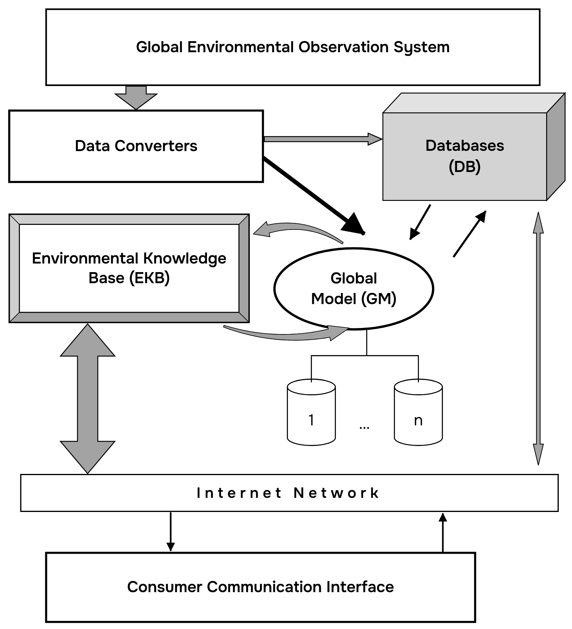
Source: author's work.
Formalization of the concept of environmental safety of a country presupposes assessing its optimal level in mathematical language using the methods of complex systems theory and survivability theory. Let us denote the national system of a country as A. Clearly, A interacts with other similar systems (let us denote them by the symbol B) having various spatial locations. All other countries are identified by the author in an approximation with a single system B, although subsequently the situation can be made more complex by considering many systems with which A interacts.
Systems A and B have their own goals, structures and behaviour (strategies). Thus, A (B) of system A(B) strives to reach certain states preferable for it. This goal may have a multifaceted hierarchical character. Its parametric representation is one of the important tasks. As an example, let us consider the following components of the goal of system A: A1 – the integral indicator Q of environmental quality across the entire territory of the country must not fall below threshold q; A2 – the maximum permissible concentrations L(i,j) (j=1, mi) of substances must not be violated on the j-th part of the country's territory in medium i (i=1 – soil; i=2 – water; i=3 – atmosphere); A3 – the economic potential of the country over time Δ t must increase by s per cent.
The goal B of system B in relation to A may be antagonistic, neutral or coalition-based, which is determined by the form of its criterial functions. The expediency of the structure |A| (|B|) and the purposefulness of the behaviour A(B) of system A(B) are evaluated by the degree of effectiveness with which the goal is achieved. The behaviour of the systems may facilitate, not hinder, or counteract the achievement both of their own goals and of the goals of the other system. In the first case, the pair of systems may be treated as a single system sharing a common goal and interacting with other systems; in other cases, one must speak of their mutual relations.
Since by systems we mean national ecological systems, it is advisable to clarify certain provisions concerning the modes of their interaction, including in the form of exchanges of certain resources (financial and technical means, natural resources, etc.). When introducing some resource V expended by a system and resource W consumed by it, an exchange (V,W) takes place between the interacting parties. Each of them strives to make it advantageous for itself. This approach makes it possible to carry out a further formalization of the functioning of the systems. Suppose that the goal of each of them is the most advantageous exchange (V,W), when each party strives for a minimum quantity of V to obtain the largest possible quantity of W, which becomes a function of the structure and behaviour of the interacting systems:
As a result, the interaction of A and B mathematically reduces to the following relations (models):
where A0 and B0 are optimal systems.
From equations (1) – (3) it is seen that in order to determine its goal, each system will have to decide what is more important for it: to obtain the most advantageous exchange (V,W) or to prevent the other system from doing so. In this case, the values of V,W exchanges vary within certain limits. Thus, W1 ≤ Wa ≤ W1, and W2 ≤ Wb ≤ W2, where W1 and W2 correspond to maximally aggressive states, while W1 and W2 correspond to the most cautious ones.
When the goals of the systems are known, a well-defined situation takes shape. If, however, the parties or one of them conceal their intentions, then a game situation regarding goal selection is present. Let us denote by Ai and Bj (i = 1,…,n; j = 1,…,m) the sets of goals of systems A and B, respectively. Goals A1 and B1 consist in inflicting maximum damage on the other side (maximum aggressiveness), whereas goals An and Bm correspond to their extremely cautious behaviour (most-favoured regime). All remaining goals are arranged along scales {i} and {j} in the order of transition from A1(B1) to An(Bm). Assuming that in situation {Ai, Bj} the systems receive payoffs Wa = aij and Wb = bij, we obtain a bimatrix game for determining the optimal goal with payoff matrices ‖aij‖ and ‖bij‖. In the special case where Wa = −Wb, the game becomes antagonistic.
Let us note that in the general case the situation should be studied in a probabilistic space, where one has to speak of some probability of each system achieving its goal – P(V,W). Moreover, it is necessary to consider various manifestations in the behaviour of systems, such as reliability, informativeness, controllability, and learnability. At the same time, their elements must have different functions and purposes, including protective, vital ones. In addition to equations (1)–(3), it is important to analyse dynamic relations describing the dependence of system parameters on time. In this case, mathematically the problem of assessing the optimal level of environmental safety of a country's territory reduces to a differential game.
At the national level, as indicated above, a multitude of criteria is present. The state is called upon to ensure compliance with well-defined sanitary-hygienic and environmental standards in given climatic situations. All of them must be forecast and serve as initial conditions when assessing environmental safety. Environmental quality is a complex constituent (function) of temperature T, wind speed U, total content of heavy metals in water E, air D and soil G; the presence of gas of the k-th type (k = 1,…,N) in the atmosphere Sk; vegetation cover biomass M and other parameters, which can be represented in the form:
Analogous operations accompany the functional representation of dependencies L(i,j) and other environmental characteristics on natural and anthropogenic changes. Furthermore, many of the parameters determining them can provide a representation (in the form of functions) of the state's investment policy. For example, the volume of investments allocated to combating pollution, developing agriculture, building roads, introducing new technologies, etc. influences environmental quality indicators. And the problem thus reduces to finding indicators of an optimal investment policy.
The totality of models of environmental parameter dynamics and the optimized relations indicated above predetermines the importance of synthesizing national policy in the sphere of environmental protection activity with the corresponding policies of neighbouring states, as well as of the entire world community. Certain aspects of such an approach to the problem under consideration are detailed in the works of domestic researchers².
Taking into account all that has been said, the primary task becomes specifying objective functions and their dependence on operating parameters in order to optimize and improve domestic and foreign national strategy in the sphere of environmental monitoring. In final form, mathematically it reduces to solving a problem for a system of parabolic differential equations as applied to the territory of the region and its conditions. In doing so, the system of equations will describe the dynamics of pollution on the territory of the state, while the conditions of the region will be determined taking into account the behavioural strategies of adjacent territories. The solution of the regional problem will enter into relations (1)–(4), which will make it possible to finally determine the optimal level of environmental safety of a specific region.
In conclusion, the author once again draws attention to the fact that the continuously growing technological expansion of human beings into the world of wild nature has today acquired global proportions. It is accompanied by the rapid destruction of natural ecosystems and disruption of the biochemical cycle, which manifests itself in dangerous failures of the stability of natural processes and in increasingly frequent catastrophic natural and climatic events. Since the late twentieth and early twenty-first centuries, changes in the natural environment have been occurring before the eyes of a single generation of people, who have increasingly come to experience their harsh impact upon themselves. The advanced modern observation systems that have emerged to monitor its parameters unambiguously confirm the unprecedented nature of the changes taking place in nature.
The approach proposed in this publication to preventing the occurrence of natural and anthropogenic emergency situations and mitigating negative consequences by creating anti-crisis situation-analysis centres based on information-modelling systems is, in its essence, innovative. With the help of GIMS technologies equipped with algorithms for searching for behaviour-optimization strategies when making management decisions to prevent major technogenic damages, instruments emerge for preventive assessment of the most probable scenarios of situation development and for working out optimal ways of responding to them. At the same time, it also becomes possible to optimize the construction of the monitoring systems themselves, the manufacturing and operating cost of which can be reduced through their integrated use jointly with mathematical models of the functioning of environmental subsystems.
The beneficial economic effect from applying GIMS technology in solving global tasks to combat the negative consequences of emergency situations increases manyfold when all national environmental control systems are used jointly. Real achievement of a positive effect is guaranteed by putting into practice the idea of creating and operating MTSGGIM. The latter is capable of helping overcome departmental barriers and opportunistic interests during the exchange of monitoring data, since through the synergy effect capabilities expand manyfold and incentives arise for developing many national control systems, in particular local anti-crisis situation-analysis centres³.
Creating a network of them will undoubtedly serve the interests of international cooperation aimed at ensuring global environmental safety, following the example of the functioning of the International Geosphere-Biosphere Programme “Global Change” initiated 30 years ago—naturally, when it is contemporarily refocused on studying the regulatory functions of the Earth's natural ecosystems.